Apparatus & Spatial Foundations
The 3D-Compass is an educational instrument designed to bridge the gap between abstract mathematical formulas and tangible, real-world vector navigation. It features perpendicularly folded semi-circle protractors ($-90^\circ$ to $+90^\circ$) representing Azimuthal ($\phi$) and Polar ($\theta$) angles, coupled with a magnetic compass for ground alignment.
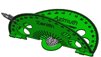
Interactive Coordinate Simulator
Manipulate the spherical parameters ($\rho, \theta, \phi$) below to observe instantaneous vector rendering in the Plotly engine and review live calculated Cartesian coordinates ($x, y, z$):
Louisiana Student Standards for Science (LSSS) Alignment
Mathematics
LSSS: F-TF.A.2 / N-VM.A.1Trigonometric functions and vector decomposition (magnitude/direction) modeled in 3D spatial volumes.
Science
LSSS: HS-ESS1-4Celestial coordinate targeting, horizon-to-equatorial conversions, and orbital frame-of-reference transformations.
Engineering
LSSS: HS-ETS1-2Application of the Engineering Design Process (EDP) to verify line-of-sight tracking and model physical instrument tolerances.
Technology
LSSS: K-12.CS.A.2Algorithmic computation and coordinate transformations for robotics navigation and sensor alignment.
Proposed 90-Minute Workshop Timeline
Introduce the physical constraints of 2D coordinates in 3D space. Define the core operational challenge: converting remote spherical radar targets into rectangular vectors for vehicle waypoint routing.
Students operate the physical 3D-Compass, reading elevation angles on the vertical protractor and azimuthal headings on the horizontal ring, computing coordinates via trigonometric identities.
Student cohorts are assigned blind spatial target problems. Teams solve coordinate systems numerically, align their physical compass needles, and test line-of-sight laser accuracy on scaled 3D classroom grids.
Teams quantify measurement error tolerances, review real-world aerospace telemetry, and link these competencies to careers in satellite tracking, avionics, and autonomous navigation.
Assessment & Measurable Outcomes
| Assessment Domain | Standard Index | Performance Competency |
|---|---|---|
| 1. Mathematical Precision | F-TF.A.2 | Correct trigonometric conversion between $(\rho, \theta, \phi)$ and $(x, y, z)$ within $\pm 0.05$ rounding accuracy. |
| 2. Model Application | SEP: Developing Models | Accurate physical reading of vertical declination and horizontal azimuth on the 3D-Compass within $\pm 1^\circ$. |
| 3. Engineering Design | HS-ETS1-2 | Iterative error minimization during physical coordinate acquisition and alignment on a scaled volume. |
| 4. Conceptual Depth | Crosscutting: Systems | Articulates the geometric differences between observer-centric horizontal coordinates and celestial equatorial coordinates. |
Bring the 3D-Compass to Your Classrooms
We invite science and mathematics supervisors to launch an East Baton Rouge Parish pilot program across 2–3 high schools, measuring empirical student gains on LSSS spatial coordinate standards.
Contact Us to Initiate a School Pilot